
Copyright © 2013 Car Rental
Hoang Su Phi Rice Terraces Travel Guide
13:59 | 31/10/2026
Hoang Su Phi Rice Terraces Travel Guide
Hoang Su Phi rice terraces fill the high valleys of western Ha Giang province, close to the Chinese border and about 300 km north of Hanoi. Generations of local ethnic minorities built them by hand, and some of the oldest fields were carved into the mountainside around 300 years ago. In 2012 the area was named a national heritage site, and it remains one of the best places in northern Vietnam to see farming that still follows the seasons.
The golden harvest from mid-September to mid-October is the peak time to come, with the flooded fields of May and June as a strong second choice. Most visitors stay two to four days, either as a side trip from the Ha Giang loop or on a direct drive from the capital with a car and local guide.
1. Best time to visit Hoang Su Phi
The fields change colour three times a year, and each season in Hoang Su Phi gives a different reason to come. Rice on these high plots is grown only once a year, from planting in late spring to cutting in autumn, so it makes sense to plan the trip around the crop rather than the weather alone.
1.1. Hoang Su Phi harvest season (September to October)
Yellow first appears in the lowest villages around the second week of September, then moves uphill week by week. By early October the higher plots are at their best, and the last ones are usually cut before the middle of the month. As the rice ripens, the fields on the slopes go from pale green to deep gold in less than ten days.
For local families, cutting the rice is the grand finale of a year of work. Whole households go out with sickles, beat the stalks against wooden threshing boxes right in the field, and carry the grain home in sacks on their backs.
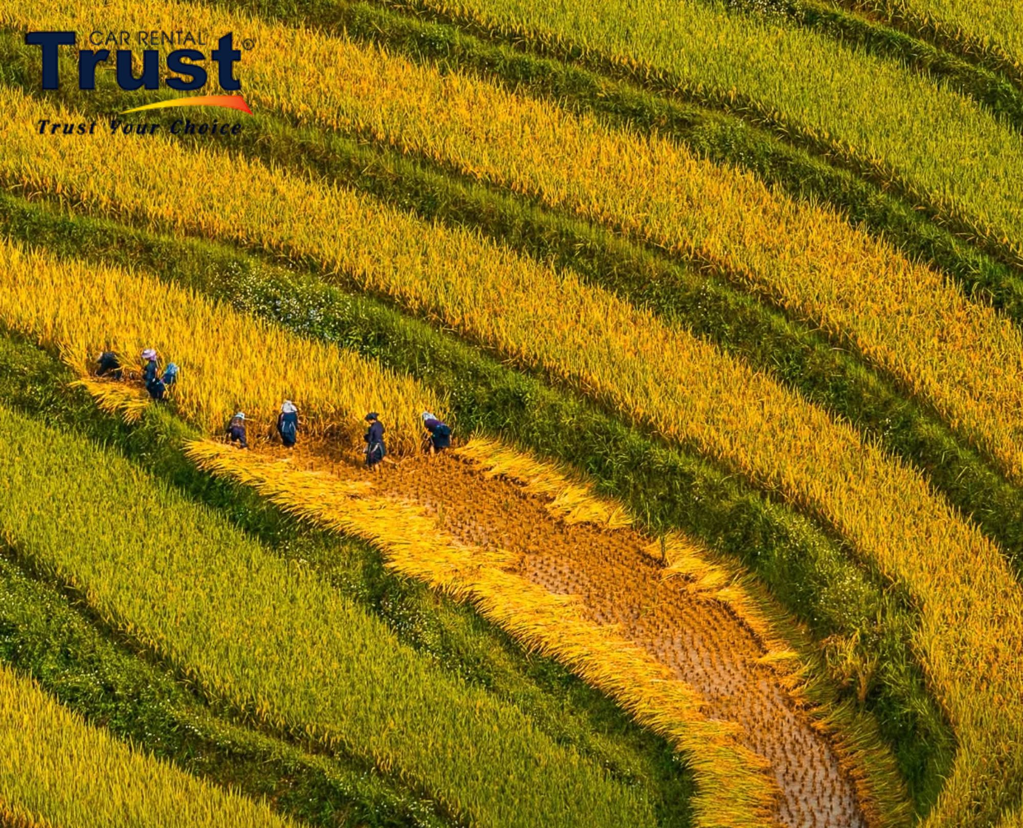
Breathtaking landscape of golden terraced rice fields during the harvest season in Hoang Su Phi, Ha Giang, Vietnam
In the late afternoon the terraces turn orange, and the low sun picks out every wall between the plots, which is the time most photographers wait for. Weekends in this period are the busiest of the year, so rooms and transport should be reserved early.
1.2. Green rice season (July and August)
About two months after planting, the young rice has filled every plot and the valleys take on a lush green colour. Visitor numbers are low, and the villages feel calm, with farmers weeding and checking water levels rather than rushing to harvest.
This is also the heart of the rainy season. Short, heavy storms often arrive in the afternoon, and small landslides can block dirt tracks to the more remote hamlets for a few hours. A morning start and one free day in the plan make this season much easier to enjoy.
1.3. Water season (May and June)
In May farmers open the small channels and let water from forest streams run down into each plot. For a few weeks the fields hold still water, and on calm days they work like mirrors, showing the sky, the clouds and the houses above them. Planting follows soon after, with whole families standing in the mud to move seedlings by hand.
The mirror effect lasts only a short time in each village, and the dates move with the rains. A local guide who knows which valley is being flooded that week is very useful at this time of year.
From November to April the fields rest. Some stay bare, while others are planted with buckwheat or vegetables, and the cold months bring clear skies and morning clouds that have their own appeal. Section 4 covers what to see in those months.
2. Top 4 places to see the fields in Hoang Su Phi
The terraced fields are spread over many valleys, and the roads between them are slow. Four places stand out for their views, their village life and how easy they are to reach.
2.1. Ban Phung
Ban Phung lies about 30 km from the former Vinh Quang town, the old administrative centre of the area. Its name comes from the Vietnamese word 'tương phùng', which means meeting or coming together, a fitting name for a place where several valleys join.
The fields here are among the highest and steepest in the area. From the road above the village, the terrace lines deep in the valley wrap around small houses with brown roofs, and the levels look narrower the higher they climb. The last stretch of road is steep and narrow, so this is a place to visit with a driver who knows the area well.
2.2. Nam Hong
This small village sits in the Thong Nguyen area and is home to the Red Dao, known locally as Dao Do. It has run a community tourism project for several years, with a shared culture house where guests can sleep, eat and join the family's daily work.
During the harvest, visitors can ask to help cut and thresh rice with a local family. It is a hands-on way to understand how much work goes into every bowl of rice served at dinner. The village is also known for Dao herbal baths, a good way to rest tired legs after a day in the fields.
2.3. Ho Thau
Ho Thau is set above 1,000 m on the slopes of the second-highest mountain in the province. The fields here are built close together in one long block, so from a high point they look like a giant staircase climbing toward the forest edge.
Cooler air means the crop turns yellow later than in the lower villages, often into the first days of October. That makes Ho Thau a good last stop for travellers who arrive late in the season, and it is also the starting point for the climb to the summit described in section 4.
2.4. Ban Luoc
Ban Luoc has more than 160 ha of rice, the largest single area of fields in the national heritage area. The village is close to the old town centre, so it is easy to reach for sunrise or a sunset stop on the way back from other valleys.
Many of the plots here are wide and gently curved, and they run right down to the houses and the stream. The paths between them are easier than in Ban Phung, which makes Ban Luoc a good choice for families or a first short walk.
3. Hoang Su Phi Ha Giang travel: how to get there
Since 1 July 2025 the province of Ha Giang has been part of Tuyen Quang, and the old Hoang Su Phi district has been replaced by new, larger local units. Maps and signposts are still catching up, but the roads, villages and travel times are the same as before, so most travellers will not notice any change.
3.1. Hoang Su Phi tour from Hanoi
Most international visitors start from Hanoi. The trip covers about 300 km and takes 7 to 8 hours by car, using the expressway toward Tuyen Quang and then smaller roads into the hills. Pickups are usually early, around 06:30 or 07:00, so there is still time for a short afternoon walk on arrival.
Direct buses also run from the capital, but they are slow, stop often and end in the town centre. From there you still need a motorbike taxi or local car to reach the fields, which can be hard to arrange without speaking Vietnamese. A tour or car hire from the capital saves time and removes most of the guesswork.
3.2. From Ha Giang city by car, bus or motorbike
Travellers already in the provincial town have a shorter trip of about 100 km, or roughly 3 hours, on a narrow road that climbs west through tea and forest. Local buses connect the two towns, but schedules change often and are best checked the day before.
Many people on the loop rent a motorbike or hire an easy rider in town and add the western valleys as a side trip. A car with a driver works just as well and is the better choice in the rainy months or for groups with luggage.
3.3. The Ha Giang loop rice terrace route
The standard loop covers the limestone plateau in the east, where there is very little rice. Ha Giang's best fields are all in the west, so the usual way to include them is to add two days before or after the loop.
An epic Ha Giang route of five or six days often starts in the provincial town, heads west to the terraces, comes back to town, and then follows the classic circuit through Quan Ba, Dong Van, the Ma Pi Leng Pass and Meo Vac. In the harvest weeks, this order puts the rice at the start of the trip while the colour is strongest.
3.4. Car with driver or motorbike: which is better
The roads to the fields are steep, narrow and often wet. A self-ride gives freedom, but it needs real experience on winding mountain roads and a valid licence, and many travel insurance policies will not pay out for unlicensed riders.
A private car with a local driver is the safer option for families, older travellers and anyone who would rather look at the view than the road. Bags stay in the car, stops can be made wherever the light is good, and the driver takes care of the narrow sections and the parking at busy viewpoints. Motorbike tours with an easy rider sit in between, giving the open-air feel of a bike without the stress of riding.
4. Things to do besides the rice fields
The crop is the main draw, but the area has enough to fill several days, including in the months when the plots are empty.
4.1. Hoang Su Phi trekking
The only way to see the terraced rice fields from the inside is on foot. Half-day and full-day walks let you explore the stunning rice terraces at farm level, following the earth walls between plots, crossing streams on log bridges and passing through a bamboo forest or two on the way up to the next hamlet.
Routes range from 2-hour loops near the old town to two-day treks that link several villages, with nights in local homestays. A Hoang Su Phi trekking tour usually includes a local guide, meals, transfers to the trail head and a bed for the night, and some operators add a porter on longer routes.
Good trekking tours keep groups small, and the guide will show you where to step so that no growing rice is damaged. For trails near the border, foreign visitors need to register with the local authorities, and guides handle this with a copy of your passport.
4.2. Buckwheat flowers in October and November
Once the rice is cut, some villages sow buckwheat on the empty fields. By late October the plots are covered in tiny pink, white and purple flowers, and the colour lasts into November. The fields here are smaller and less famous than those on the rocky plateau in the east, which means fewer crowds and easier photos.
4.3. Cloud hunting at Chieu Lau Thi peak
At 2,402 m, the peak is the second highest in the province and one of the best spots in the north to watch a sea of clouds. The trail starts near Ho Thau and climbs through tea gardens and old forest, and the view from the top has a wild beauty that few visitors expect.
Most groups leave around 04:00 to reach the summit by sunrise, while others camp near the top the night before. November and December give the most reliable clouds, but nights are cold and the path turns muddy after rain, so a local guide, warm layers and boots with good grip are all needed.
4.4. The Sunday market
The weekly market in Hoàng Su Phì commune runs every Sunday morning below Tay Con Linh mountain. Dao, Tay, Nung, La Chi and H'Mong families walk or ride in from the villages to sell vegetables, piglets, tea and handmade cloth, and to catch up with friends over noodles or a cup of corn wine.
The busiest hours are between 07:00 and 09:00, before many sellers head home. Embroidered bags, scarves and silver jewellery make good small souvenirs, and prices are usually lower than in the tourist shops of bigger towns.
4.5. Shan Tuyet tea
The tea hills of the higher villages produce Shan Tuyet, the local speciality. The leaves are picked by hand from tall, old trees, and many families still roast them in pans over a wood fire. The first sip is slightly bitter, followed by a long, sweet aftertaste.
A visit to one of the tea fields around Nam Ty or Ho Thau shows the whole process, from picking to rolling and drying. A bag of dried leaves is a light gift to take home, and buying direct from a family puts the money straight into the village.
4.6. A night with a local family
The area is home to diverse ethnic groups, and an overnight stay is the easiest way to learn about local life and ethnic culture. Many hosts are Red Dao or H'Mong families, while the La Chi ethnic group, one of the smallest in the country, lives mostly in this part of the north. Rooms are usually in a wooden stilt house or an earth-walled home, with mattresses, blankets and mosquito nets in a shared loft.
Local cuisine at a family house is simple and filling. Dinner often includes sticky rice, smoked pork, wild greens, chicken cooked with forest herbs and a round of rice wine for guests.
After the meal there is often time to sit by the fire, and in the Thong Nguyen valley many families also offer herbal baths made from leaves gathered in the forest. The fields and ethnic villages are at their liveliest in the early morning, when buffalo head out and children walk to school, so an early night is worth it.
5. Helpful notes for your trip
A little planning goes a long way in a remote area with slow roads and limited services. The points below come up again and again with first-time visitors.
5.1. Take the roads seriously
The roads into the valleys are narrow, with steep slopes, blind corners and loose gravel after rain. Trucks carrying building materials use the same lanes, and fog can cut visibility to a few metres on winter mornings. Night driving is best avoided, and in mountainous areas it is wise to add an hour to any travel time shown on a map app.
5.2. Plan your photos around the light
The fields look flat and pale at midday, when the sun is overhead. The hour after sunrise and the two hours before sunset give much better shape and colour, especially on ripe rice. A wide lens or a phone with a wide setting helps with the big valley views, while a zoom is useful for picking out farmers at work on far-off plots. Rules on drones near the border are strict, so it is better to ask your guide before flying one.
5.3. Give yourself enough days
Plans that try to explore Hoang Su Phi in a single day mostly end up as long hours in the car. Two full days on the ground is a sensible minimum, which means three to four days in total from the capital. With one more day, you can add a longer walk or the summit climb without rushing.
5.4. Money, signal and paperwork
ATMs are found only in the town centre, and family homestays, small shops and guides in the villages take Vietnamese dong in cash. Mobile data from Viettel works in most villages, but other networks can drop out in the deeper valleys, so a local SIM or eSIM bought on arrival is useful.
The e-visa, open to all nationalities, lets visitors enter Vietnam for up to 90 days, and some passports qualify for shorter visa-free entry. Travellers with a longer stay in Vietnam can build the valleys into a northern route that continues east to Cao Bang for Ban Gioc waterfall, or back through Hanoi to Ha Long Bay. If this is your first trip to Vietnam, two to three days here makes a quiet contrast with the busier stops on the classic route.
6. FAQs
6.1. How far are the terraces from Hanoi?
The valleys are about 300 km north of Hanoi, a drive of 7 to 8 hours with a lunch stop. From the provincial town in the east, the trip is shorter, at around 100 km or 3 hours on a narrow mountain road.
6.2. Which month has the most golden rice?
Late September is usually the peak, when both the lower and middle villages are yellow at the same time. The higher fields around Ho Thau stay golden into early October, so travellers arriving later in the season should head uphill.
6.3. How many days should I plan?
Three days is enough for one long walk, a sunrise viewpoint and a night with a local family. Four days allows a second base in the higher villages, and five or six days are needed to combine the area with the eastern loop.
6.4. Is it safe to ride a motorbike there myself?
The roads are paved but narrow, steep and often wet, with sharp bends and heavy trucks. Only riders with mountain experience and a valid licence should try it, and most travellers are safer and more relaxed in a car with a local driver or on the back of an easy rider's bike.
6.5. Do foreigners need a permit?
The main villages and viewpoints need no special paperwork. Trails and hamlets close to the Chinese border do require registration with local authorities, and a licensed guide or tour operator can arrange it with a copy of your passport.
6.6. How hard are the walks?
Most village walks are easy to moderate, with ups and downs on dirt paths and the earth walls between plots. Full-day routes and the summit climb need good fitness, and all paths become slippery after rain, so shoes with good grip matter more than heavy boots.
6.7. Can I visit with children or older parents?
Yes, as long as the plan stays gentle. Short loops near Ban Luoc, viewpoints reached by car and a comfortable guesthouse in the town centre suit mixed-age groups, and a car with a driver means no one has to walk further than they want.
6.8. What should I pack?
A rain jacket, a warm layer, sun protection and comfortable walking shoes are useful in every season. From November to February a down jacket is needed for the evenings, and cash in Vietnamese dong is important, as cards are rarely accepted outside the town centre.
6.9. Where can I stay?
The choice ranges from simple family homestay rooms in the villages to small guesthouses in the town centre and a few eco-lodges in the lower valley. During the harvest weeks every option fills up quickly, so it is best to book two to three weeks ahead.
7. Plan your trip with our team
The beauty of Hoang Su Phi is easiest to enjoy when the logistics are sorted before you arrive. Our team arranges cars with drivers from the capital or the provincial town, with hotel pickup, flexible stops at viewpoints and a driver who stays with you for the whole trip. We can also connect you with local guides and host families, and time the route for the May planting weeks, the golden harvest or the quiet cloud season.
A quote needs only three details: your travel dates, the number of people and the villages you would like to see. Once we have them, our team replies with a clear price, a list of what is included and a suggested day-by-day plan.
Other news
- How to Visit Meo Vac Sinkhole: Location & Itinerary (23/10/2026)
- Suoi Thau Grassland Travel Guide: Best Time, Routes & Tips (14/10/2026)
- Cu Chi Tunnel Viet Nam Guide: Tickets, Hours & Tips (02/10/2026)
- Top 10 Reputable Currency Exchange In Hanoi 2026 (26/02/2026)
- Latest Sun World Vung Tau Ticket Prices And Travel Guide (29/01/2026)
- Top 10+ Muine Seafood Restaurants You Must Try in 2026 (22/01/2026)
- Top 10 Biggest Shopping Malls In Saigon (13/01/2026)
- Top 10 Halal Restaurant in Ho Chi Minh City Must Try (23/12/2025)
- Emergency Contact in Vietnam For Travelers Should Know (31/10/2025)
- Top 5 Best Places To Currency Exchange In Sai Gon (15/10/2025)